In this project, Naturalis Biodiversity Center is working with Green Nets on the mapping of opportunities to strengthen biodiversity. Green Nets has a unique position and the potential to form a national natural infrastructure, in order to contribute to large-scale biodiversity recovery in the Netherlands.
EcologicalMain Infrastructure
Green Nets is a collaboration of infrastructure companies in the Netherlands: Alliander, Enexis Gasunie, KPN, ProRail, Rijkswaterstaat, Stedin and TenneT. The participants work on various projects within four key themes: climate, circularity, biodiversity and measuring impact. Within biodiversity, we are looking at creating an 'Ecological Main Infrastructure' within a large part of the almost 1000 km2 of acreage that the parties manage together.
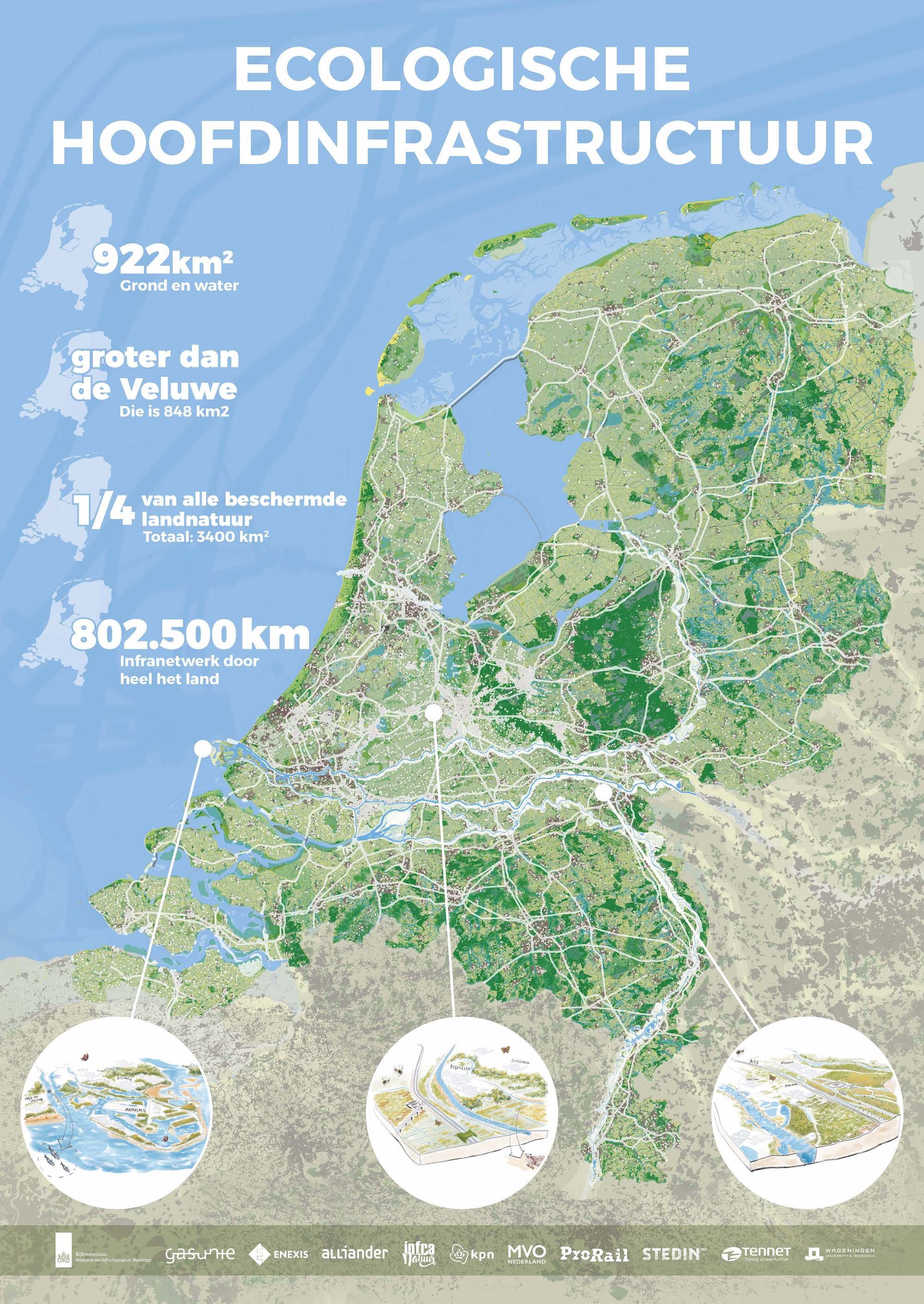
In white, the map displays the areas used by the infrastructure partners which forms the basis of the biodiversity opportunity map.
BiodiversityOpportunity Map
This network of sites will serve as the basis for the biodiversity opportunity map. The main objective is to make maximum use of the acreage to enhance biodiversity.
The Biodiversity Opportunity Map answers the question: 'What are the opportunities in the Green Nets area to strengthen biodiversity?' The opportunities are mapped out by cleverly combining information from the Green Nets parties with biodiversity data for the entire Netherlands.
The map is being developed in order to subsequently utilize these opportunities for biodiversity by implementing concrete projects.
Natural infrastructureOverview of actions
To obtain an overview of actions that have a real impact on biodiversity, Stedin and Naturalis have drawn up a list of possible infrastructure measures for design, construction, adjustments to acreage, infrastructure and (nature) management.
By collecting an expert opinion from about forty (urban) ecologists and biologists, an overview has been created with fifty concrete nature-inclusive measures that the Green Nets and other organizations can implement on and around their infrastructure. It shows what is possible in and around grid operators' property to strengthen biodiversity and thus contribute to a healthy and future-proof infrastructure.
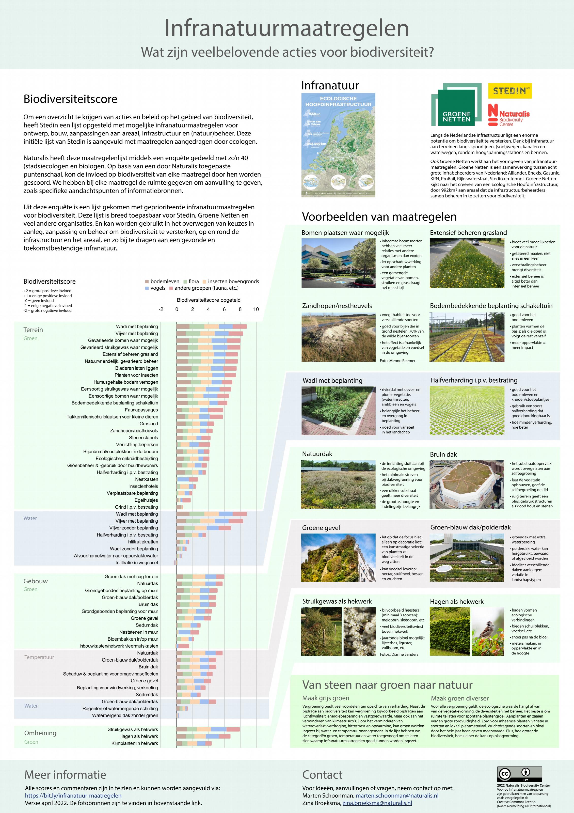 Natural infrastructure measures overview
More information can be found on NatureToday - What are promising actions for biodiversity within the Dutch infrastructure?
The overview of infrastructure measures is available here with the accompanying spreadsheet with detailed data.
Approach
Two types of data are used:
I. Data from the infrastructure partners:
- Partners basemap with the areas (polygons in GIS terminology) on a scale of 100 by 100 meters
- Collaboration opportunities with partners is a map layer where the number of adjacent infrastructure partners per location are shown
- Nature management map with current management per area such as ecological or non-ecological mowing management expressed in a list of specific management types per area.
II. Nature-related data that say something about strengthening biodiversity:
- Make gray greener map layer: gray and green locations of the areas. This map layer answers the question: 'What is gray on the map and where can paving and roofs be made greener?'
- Make green more diverse answers the question: 'Which type of greenery suits my location best?'. This habitat opportunity map indicates which habitat best suits that location (most likely to thrive with high species diversity and healthy populations) based on extensive data analyses (prediction models) by Naturalis based on millions of nature observations of species typical of the different habitats . The current habitat in the area can also be consulted.
- Connect green is a map layer showing the proximity of (protected) nature reserves within NatuurNetwerk Nederland (NNN). This provides information about the possible expansion of those nature reserves on your own property or the construction of wildlife passages or other measures based on ecological advice
Naturalis has combined the above map layers into a general opportunity map using a calculation model with points per block of 100x100 m per map layer. On this aggregated map layer, the total scores of the individual map layers are added up and thus shows the most promising locations for achieving improvements on several topics as indicated above and for taking advantage of opportunities (for example, cooperation in greening).
The maps are presented in an ArcGIS Storymap website for access by Groene Netten partners. This also includes a map layer for example projects.
To know which measures can be implemented in practice, the following knowledge products can be consulted:
- Nature-inclusive measures that can be taken (see the poster above) made in collaboration with Stedin
- Nature-inclusive construction in collaboration withKPN
- Roadside management in collaboration with ProRail and Hochtief
- Biodiversity management model in collaboration with Alliander and Impact Institute
In addition to these tools, there are also on the Biodiversity Toolbox various sources can be found under for example Construction and infrastructure companies and TenneT offers a Inspirational guide to nature-inclusive construction.
The above approach is further explained in this Youtube recording